EdgeAI + 5G · One View, One C2
Every autonomous machine gets a brain — Edge AI, flight control and 5G — and one cloud to command them all. One view, one C2 for your entire fleet, with live AI detections on a single screen.

Edge AI · Live Detection
On-board detection isolating people and vehicles in real time — the same Edge AI that runs on every DroneAI platform, at the edge, over 5G.
AI Use Cases
The same on‑board EdgeAI, retrained per mission — from crowd analytics and traffic to defence ISR, fire correction and autonomous navigation.


How EdgeAI works
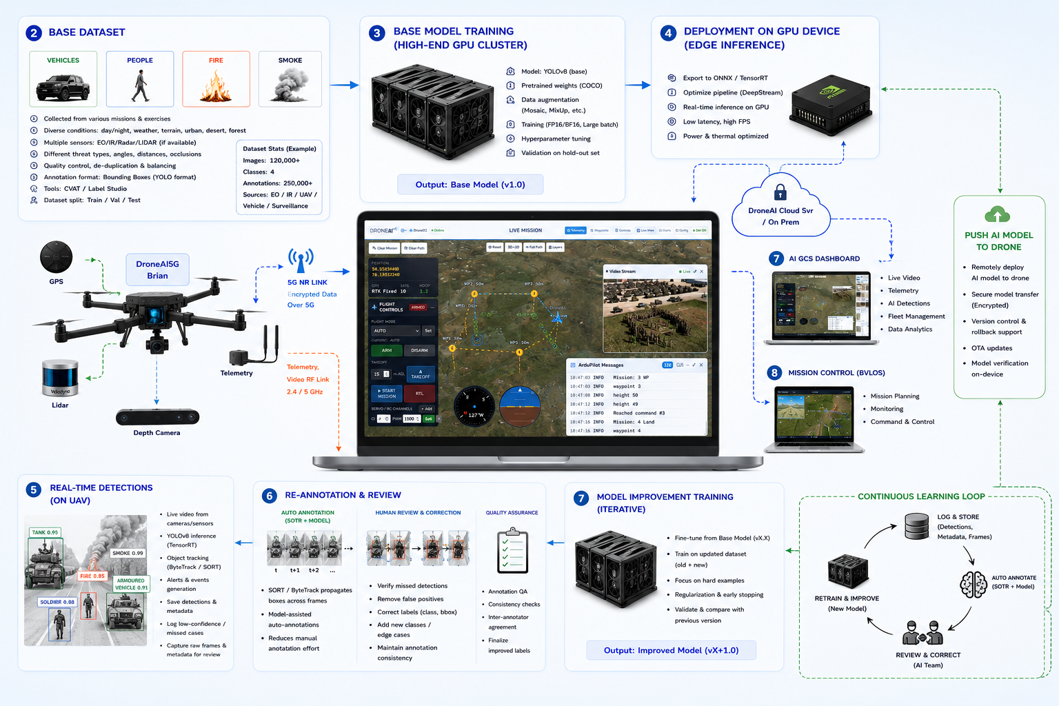
Models are trained on a GPU cluster, optimised for on‑board inference, and run at the edge on the aircraft. Detections stream over 5G to the cloud, while field data feeds a continuous retraining loop — and improved models are pushed straight back to the drone.
DroneAI Cloud · Command & Control
Plan, fly and command drones, rovers and vessels from a single console — a live map, video and geotagged AI detections in one view, with beyond‑line‑of‑sight control over encrypted 5G.
Cloud

Click a view to open it on the console.
5G · Remote Operation
5G turns the radio-range limit into a network-range platform: beyond‑line‑of‑sight control, drone delivery and a live digital twin — on public or private 5G.
No RF-range ceiling — command drones and robots over the cellular network, city-wide and beyond, with automatic link failover.
5G-connected drone delivery — dispatch, track and control every sortie from the cloud, at range.
A live digital twin of every machine — telemetry, video and 3D position mirrored in the cloud in real time, and fully replayable.
Runs on private 5G with an on‑prem VPN — encrypted end‑to‑end, so your data never leaves your network.
BVLOS · 5G
BVLOS lets one operator supervise many drones, reach the length of a pipeline or a delivery route, and get to an emergency before the patrol car. The question is whether the drone has a link you can trust.
All traffic is authenticated and encrypted, and drones only make outbound connections.
Drones launch from the station and stream video before the patrol car arrives; the district control room sees every flight, recorded for evidence.
One operations room runs many routes, planned on coverage maps, with dual SIMs for long routes and live video to confirm each drop.
At the Amlohri coal mine (C-DAC private 5G), drones and trucks shared one network and one dashboard — pits and shadow zones covered, data kept on site.
Point clouds stream live, so gaps are spotted and re-flown on the spot — stockpiles, corridors, construction and disaster zones.
Patrols along long fences and borders beyond visual range, with geo-tagged AI alerts and a dual-operator link across coverage gaps.
Scheduled BVLOS patrols of pipelines, power lines, solar parks and plants — every patrol recorded and comparable over time.
After floods or earthquakes, drones search wide areas and feed the command centre live, with AI flagging people who need rescue.
Drones, rovers and trucks on one network and one map — the same link and the same operating picture.
Product brochure 2026 · Edge AI · 5G · C2 · AI Studio
Onboard Edge AI, a 5G link, DroneAI C2 and your own AI training with DroneAI Studio — for the drones and rovers already in service. Built for security forces: Army, BSF, CISF.
Drones already observe. Recognising, deciding and acting still run at human speed. DroneAI adds onboard Edge AI, 5G and a Common Operating Picture (COP) to the drones you already operate.
Today: operators watch feeds for hours and miss small targets.
With DroneAI: Edge AI detects persons, vehicles and drones, day and night.
Today: what the drone sees stays on the pilot's screen.
With DroneAI: every detection reaches the C2 map as a geo-tagged alert in seconds.
Today: DRI by eye; footage re-checked after landing.
With DroneAI: automated DRI, with targets ranked by priority.
Today: response cued late, by radio.
With DroneAI: task the nearest drone from the detection; grid shared with the response team.
Detection, recognition and identification run on the drone, on EO and thermal video. Each result reaches the control room as a record — class, confidence, time, location — that can be mapped, searched and reported.
| Critical infrastructure · CISF | Perimeter intrusion alerts at airports, ports, refineries and power plants, with location on the control-room COP. |
| Border and creeks · BSF | People at the fence and boats in creeks and riverine borders, detected at night; animals filtered out. |
| Unit perimeter · Army | Counter-infiltration along tree lines and approaches; every sortie saved and searchable. |
Connectivity · Nothing removed, nothing retrained
One DroneAI module joins the flight controller, camera and RC radio you already have. The pilot keeps the RF link; encrypted 4G/5G adds a link to DroneAI C2. The same wiring applies to every upgrade kit.
Telemetry to the flight controller, Ethernet to the camera and RC air unit, 5 V power and a SIM. That is the whole install.
Encrypted video, telemetry and detections to DroneAI C2, on DroneAI cloud or your own servers.
The existing 2.4 GHz link still serves the pilot, now with AI detections on the camera feed.
| AI + 5G on the drone | EdgeAI5G Lite (small drones) · EdgeAI5G (larger drones, UGVs) |
| 5G link only | Telem5G, for any MAVLink drone |
| Server, dashboard, mission control | DroneAI C2, cloud or on-prem |
| Ground station and RC | Your existing pilot GCS and 2.4 GHz radio |
| Building a new drone? | CubeAI5G and Cube5G — see new drone builds |
Upgrade kits · The right kit for each drone
All three are wired the same way and connect to DroneAI C2.
Best for: small and FPV drones
Best for: larger drones and UGVs
Best for: BVLOS control of any MAVLink drone
| Small or FPV drone; AI and 5G | EdgeAI5G Lite |
| Larger drone or UGV; heavier AI and tracking | EdgeAI5G |
| Closed commercial drone | EdgeAI5G Lite or EdgeAI5G at the ground station |
| Long-range control and video only | Telem5G |
Onboard AI · The AI does the watching
Eight AI jobs run on the drone itself. Everything is processed on board; only the results and the video go over the link.
People, vehicles and armour, in day and thermal video.
Lat/long, time and confidence for each detection.
One tap to lock; the drone keeps the target centred.
Live headcount and density over an area.
Vehicles detected and counted per minute.
Spotted early, from the air.
AI computes the release point for payload drops.
Bunkers, camps, new threats — via DroneAI Studio.
The pilot sees it too: the pilot dashboard runs on a tablet connected to the RC controller, with live video, AI detections, the map and flight controls. The commander sees the same on C2 over 5G.
Detection, recognition and identification run on the drone itself. Only the result has to travel: class, confidence, time and location, with video when the link allows.
| 1 · Capture | EO and thermal video from the camera already on the drone. |
| 2 · Detect | Every frame, tiled so that small, distant targets are found. |
| 3 · Recognise | Class and confidence for each target, tracked across frames. |
| 4 · Geo-tag | Position from drone GPS, altitude and camera angle. |
| 5 · Alert | To the pilot tablet and DroneAI C2 in seconds. |
Persons and vehicles only a few pixels wide, found by tiled inference.
Runs on EO and thermal (IR) cameras.
Detection continues on board; results are sent when the link returns.
When video cannot pass, detections still go through as small data packets.
Each target keeps an ID, so the drone can lock on and follow.
New classes are added with DroneAI Studio.
Software · Command and control · One common operating picture
One COP for every drone and rover you fly, whatever the make. Fly, watch, find and act from one browser screen.
Every drone, battery and link status.
All feeds with AI boxes and alerts.
Waypoints, routes, live progress.
Launch a drone from a detection.
What changed since day one.
Detections for any 1 km, as PDF.
Video, track, detections and logs.
One command for a whole group.
Encrypted, per-user access, VPN/TLS.
Same detections on the GCS.
AI models and firmware, with rollback.
DroneAI cloud or your own servers.
DroneAI C2 puts the pilot, the commander and headquarters on the same picture, so a detection becomes a decision in seconds.
| 1 · Alert | A geo-tagged detection arrives on the map. |
| 2 · Verify | Live video and track, one click away. |
| 3 · Task | Send the nearest drone to the spot. |
| 4 · Share | Grid and video to the response team. |
| 5 · Review | Replay the sortie; export the area report. |
Tablet on the RC: live video, AI boxes, map and flight controls.
Every drone and alert of the unit, video wall and tasking.
Picture across units, with replay and reports.
DroneAI Studio · On-prem AI training · New threat, new model, in days
Every sortie makes your models better. Footage, labels and training stay on your own GPU servers, and improved models go back to the fleet over the air.
Labelled EO and IR data from missions and exercises, trained on a GPU cluster.
Optimised for the onboard GPU: real-time, low power.
Detections, tracks and frames logged for review.
Re-annotate, retrain, verify; push to every drone, with rollback.
Footage from every sortie is stored on your servers. Your team marks a new target once, the model is retrained on your GPU server, and the update goes to every drone.
Your data stays with you. Footage, labels and models stay on your own network. Nothing is sent to DroneAI unless you choose to.
Vehicles that the standard model does not know.
Bunkers, camps and hides, from your own imagery.
Boats typical of your creeks and coastline.
Small drones seen in your sector.
Persons and objects that appear only a few pixels wide.
Night-time patterns from your own IR footage.
Beyond drones · One platform, air and ground
The same onboard AI and DroneAI C2 also run on ground robots (over 5G) and unmanned boats (over their own radio link).
Also in service: DroneAI 5G telemetry and C2 run dumper trucks on a private 5G network.
For new drone builds · Faster to field for manufacturers
For manufacturers and integrators. These units include the flight controller, so they go into new platforms rather than upgrades.
One unit with flight controller, AI processor and 5G modem.
Telem5G combined with a Cube flight controller.
Visual and terrain matching keeps the drone on its route when GPS is jammed, spoofed or lost. For upgrade kits and new builds.
Flight controller, GPU AI and 5G on one board, sized for small, FPV and interceptor drones.
Hardware · Intelligence at the Edge
EdgeAI OS runs detection on a dedicated on‑board AI processor — so the mission keeps thinking even when the link doesn't. Every DroneAI unit carries that intelligence at the edge and streams encrypted over 5G to one C2 Cloud, from an all‑in‑one AI module to a rugged telemetry link.


Flagship · Integrated Mission Platform
The complete brain for an autonomous machine in a single module — the EdgeAI OS and a dedicated AI processor running detection models, a Cube Orange+ class flight controller, a 5G modem and secure telemetry. Because inference runs on-board, the mission keeps thinking even when the link drops; detections are made at the edge and streamed over 5G to the C2 Cloud. The same module fits a UAV, a UGV or a USV.


Connectivity · Link Resilience
The connectivity-first member of the family, built so the link is never the weak point. It layers three paths — low-latency 2.4 GHz RF for line-of-sight, NR 5G for cellular range, and Starlink for anywhere else. When one drops, the next takes over automatically, orchestrated from the cloud — genuine BVLOS for long-range, denied and maritime missions. The Cube 5G SL variant carries Starlink integrated on the airframe itself.

Retrofit Kit
Make the fleet you already own intelligent. A compact companion computer bolts onto a drone or rover you already operate — mount the unit and your existing airframe gains on-board AI detection and a 5G link. Detection runs locally, so intelligence doesn't depend on the network; encrypted telemetry and detections stream over 5G to the cloud for fleet-wide visibility. Compatible with standard ArduPilot and PX4 vehicles.

Connectivity · Telemetry
Rugged 5G telemetry, nothing else to go wrong. The Telem5G-As140 bridges MAVLink and mission data across the cellular network so the flight controller and ground station stay in sync at range — no on-board AI, just rock-solid connectivity. Dual antenna sets for 5G and WiFi, a UART port for external GNSS, plus CAN and Ethernet to the autopilot and payloads, all in a sealed aluminium heat-sink case built for the field.

Lightweight · FPV & Lite Drones
Edge AI in a reduced form factor — a two‑piece system sized for FPV and lite drones that can't carry a full module. A compact AI Unit (5×8×3 cm) and a 5G Unit (7.5×4×2.5 cm) join by an extender cable, so they fit where a full unit won't. The 5G Unit carries the SIM and antenna array; a JST Ethernet port takes an IP camera, telemetry wires straight to the flight controller, and the whole system runs off 5V (XT30). Same on‑board detection and encrypted 5G streaming as the rest of the line — lighter and lower‑power.
Use Cases
Deployed with defence & industry leaders
Events & Press
From India Mobile Congress to CENJOWS, GITEX and Bharat Drone Manthan — DroneAI on show with the armed forces, telecom operators and the wider drone ecosystem.

Team
Operators and engineers building the single platform for autonomous robots.

Founder of Emvirt Solutions, building DroneAI — EdgeAI + 5G for every autonomous machine.
LinkedIn
UAV platforms, integration and flight-test across the DroneAI hardware line.
LinkedInSoftware & systems engineering across the DroneAI platform.
Advisors
Defence and aviation veterans advising DroneAI on mission, airworthiness and deployment.
Tell us about your platform and mission — we'll show you the fastest path from prototype to deployment.